N.O.A.A. delivers aerial imagery of Tuscaloosa, Ala. tornado damage
|

 |
Category: Trash and RecyclingType: News
Source: National Oceanic and Atmospheric Administration
Date: Saturday, April 30th, 2011
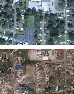
Before and after imagery depicting tornado damage in the vicinity of the intersection of 15th Saint E. and McFarland Blvd. E. in southeast Tuscaloosa, AL. The before imagery is courtesy of Google, the after imagery was acquired from an altitude of 5,000 feet above ground level by the N.O.A.A. King Air April 29, 2011.
Hi-Res images accessible online.
Download PDF here. (Credit: Google - before photo; N.O.A.A. - after photo)
NOAA's National Geodetic Survey dispatched the N.O.A.A. King Air 350CER aircraft, equipped with specialized remote sensing equipment, on a mission to collect aerial photography at 5,000 feet from Tuscaloosa to Birmingham, Ala.
These "before and after" shots (pdf to right), taken yesterday afternoon, show damage caused by last week's tornado near 15th Street and McFarland Boulevard in Tuscaloosa.
Photos will be used to assist federal and local officials in response and recovery efforts.
Hi-Res images accessible online.
For more information, contact: John Ewald, [email protected], 240-429-6127.
NOAA's mission is to understand and predict changes in the Earth's environment, from the depths of the ocean to the surface of the sun, and to conserve and manage our coastal and marine resources. Visit us on Facebook.
There are currently no comments for this story. Be the first to
add a comment!
Click here to add a comment about this story.


